
Liviu Stoica
Co-Founder/ Topographer Engineer

Radu Ionică
Co-Founder/ Topographer Engineer

Liviu Zarnovean
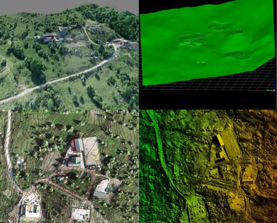
My opinion about TopGIS Engineering? It is one of the most serious companies. It does more than it promises and faster! I met Liviu Stoica in an elite entrepreneurial environment, in a famous business club in Brasov. And I got to work with him in a short time, because I quickly realized that I was dealing with a man totally dedicated to his passion for modern topography. In fact, he opened my eyes to 3D laser scanning and aerial photography with specialized drones. The results we received from TopGIS following the scans for projects such as "Residential complex Bartolomeu - Sprenghi", or "Hotel la Bran" helped us a lot to develop concepts perfectly integrated in the context and offered us a favorable positioning in front of our clients. Undoubtedly, more projects will follow with the TopGIS team. I recommend them with all confidence!

Codrut Ungureanu
After a collaboration of almost 4 years, we can only recommend with all confidence the TOPGIS Engineering team for the promptness with which they respond to all our requests, for the solutions brought in the moments of the company and for the professionalism with which they treat each requirement, even when they are not. just simple. Thank you and see you at the next mission.

Marian Petrescu
The team from TOPGIS ENGINEERING helped me to make an orthophotoplan and a topographic plan for my location (plans made with a drone in a few hours on an area of 2ha). I plan to make certain constructions in that area and without their help I would not have been able to know exactly what the level differences are and where I can build what I set out to do. Moreover, due to the realization of the plans with the drone, I managed to save a lot of time (days), time that I used to advance with the rest of the stages of the project. I had a very good collaboration with them and I warmly recommend them.

Cristian Coman
Melsam Construction started the collaboration with Topgis Engineering for topographic measurements and engineering topography in the project of building blocks of flats in Brasov, TOPCITY and Mall AFI Palace Brasov. The services offered in the two projects are characterized by professionalism, compliance with the established deadlines as well as by the effectiveness of the solutions that came to meet the existing needs in the projects. Following the very good collaboration, we confidently recommend the services offered by Topgis Engineering.

Vlad Lazaroiu
As a beneficiary of the services offered by TOPGIS Engineering, within the numerous projects, I appreciate the quality and professionalism they have shown. I recommend with confidence.

Paul Paicu
I turned to this company for cadastral services and forest topography, the collaboration was a successful one and I confidently recommend the consultancy provided.


Co-Founder/ Topographer Engineer

Co-Founder/ Topographer Engineer

Geodesist
Engineer
Engineer

Topographer
Engineer
Engineer


